Approximately 50 years ago, Alaska was admitted as the 49th state of the United States . Europeans first discovered this land in 1741
when a Danish-born navigator, Vitus Bering, who was serving in the Russian
Navy, was on an expedition around the northern Pacific
Ocean . During this
expedition, he sighted land on the southern coast of Alaska ,
in an area known as Kayak Island , in addition to the Aleutian
Islands . Another vessel,
captained by On October
18, 1867, the land was purchased by the United States for approximately $7.2
million dollars. Alaska has many geographic landscapes within
its boundaries; some of which have helped its economy and others which may it
difficult for settlements to survive.
Gold and oil have had a significant impact on Alaska ’s geographical landscapes, while the
climate has prohibited development in many places across the vast region.
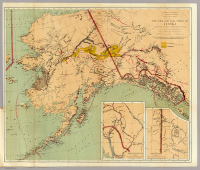
Figure 1: Map published in 1898 and covers areas abundant
in gold and coal
Another major improvement to Alaska ’s economy was the opening of vast
oilfields in northern part of the state.
In the 1970’s, the United States authorized a pipeline to be built to
transport the oil from the Arctic Ocean at Prudhoe Bay to the Gulf of Alaska at
Valdez. The pipeline, which is called
the Trans-Alaska Pipeline System, runs approximately 800 miles between these
two areas and has transported over 15 billion barrels of oil since it was built. In Valdez , the
oil is then shipped from the port of Valdez to the mainland of the United States for further
refining. Supposedly, there is also a
great abundance of oil that can be found in the Arctic National Wildlife
Refugee (ANWR), located in northeastern Alaska
and other areas of the Arctic ; however,
environmentalists continually fight the possibility of drilling in this tundra
region. In an article by Mitchell, he
states “much of the debate over whether to drill in ANWR rests on the amount of
economically recoverable oil, as it relates to world oil markets, weighed
against the potential harm oil exploration might have upon the natural wildlife.” Some of the animals, birds, and mammals in
these habitats that would be affected include caribou, polar bears, walrus, and
whales, among other species. In addition
to damaging the habitats of these animals, there is also political and cultural
landscapes affected. Politically, the
Canadian government opposes anytime type of drilling in this area due to the
shared boundary with the Yukon
Province United States to treat these lands
with the same respect. Since the
discovery of oil in Alaska ,
it has become a major revenue of the state, in addition to income for many
Alaskans. The residents of the state
along with the Alaskan government are for the idea of drilling in these
protected lands because it will increase profit and revenue for them from the
oil leasing. The Native Americans of the
geographic region have split views on whether to drill or not depending on
where they live. For instance, the
Inupiat Eskimos who live north of the mountains named Brooks Range, are for
onshore drilling, but oppose to offshore drilling; where as the Gwich’in
Indians, south of the Brooks Range , pose the
drilling as a threat to their environment.
Other supporters of the drilling argue that the oil able to be salvaged
beneath northern Alaska ’s tundra could equate
to many decades of importing oil from the Middle East . This would decrease our dependency on oil
from foreign countries and reinvest our money in our own economy vice in a
foreign government. Regardless, of the
aforementioned pros and cons, there still has not been enough research to
determine how the drilling would really affect the geographic landscape of
northern Alaska . Many of the geographic landscapes affected by
the extraction of petroleum have had similar results to Alaska ’s economy as in the gold rush. Petroleum extracts make up the majority of
revenue for the state of Alaska .
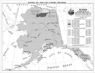
Figure 2: Map published in 1999 by the State of Alaska ’s Oil and Gas
Division
The physical
geography of Alaska
is mostly mountainous with 14 ranges covering the majority of area within the
state, along with hills, valleys, and rivers.
Natural disasters such as earthquakes and volcanoes are known to have helped
shape the geography of Alaska
over the past millions of years. In
addition, Alaska is surrounded by water on
three of its sides: Arctic Ocean to the North, Bering Sea to the West,
and the Pacific Ocean to the South. The total area of these three bodies of water
consists for 43,887 miles of the coastline.
However, most of Alaska ’s
physical geography is very remote and inhabitable and covers approximately 590,
804 square miles. It is extremely cold
making it very difficult for any type of agriculture, cultivation, extensive
development, or permanent settlement for most people. The largest city, Anchorage , does not have more than 300,000
people residing in it. Most of the northern
lands are tundra and permafrost.
Permafrost consumes about 80% of Alaska
and impacts the physical infrastructure of Alaska .
Constructing buildings over permafrost could cause it to melt resulting
in the buildings to partially sink.
Similarly, roads in permafrost areas can cause the subsurface to melt
resulting in road depressions and expensive repairs. Since it is so inhabitable, the region has not
been explored in great detail; however, in addition to what has already been
found, it is possible there may be even more resources in gold and oil that
have not been found and which would be very beneficial to Alaska .
In conclusion, many industries
have been established in Alaska . Gold, copper, and coal mines have been
created from the abundance of resources located within or near the various
mountain ranges in this geographic region.
In addition, oil and gas pump stations have been created from various
regions in the north. Since the land is
so remote, railroads and pipelines have been built to transport theses
resources to other parts of the country, mainly through the ports of Valdez and Seward. Unfortunately, between the northern and
southern regions of Alaska ,
the land is extremely rugged and unstable, with three mountain ranges,
permafrost, rivers and streams, and many migration paths for animals, in
addition to active fault lines. As a
result, the geological activity between the north and the south has caused many
problems for the pipeline, as well as the railroad, which does not travel as
far north.


